1904 Boundary Map of Glenwood Cemetery
Archive
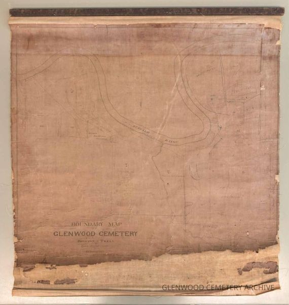
This large-format linen boundary map, created by the Houston engineering firm Whitty & Taylor in March 1904, illustrates Glenwood Cemetery and its surrounding landscape. The map outlines Glenwood's official property lines, adjacent roads, and nearby burial grounds, including the Catholic Division and the German Lutheran Cemetery, as well as areas designated as "Forest Mound," "Hillside," and "New Strangers Rest." The detailed inkwork captures topographical features, including Buffalo Bayou, roadways, and elevation contours, providing a view of the cemetery's natural landscape and constructed divisions during the early 20th century. Handwritten annotations indicate section letters and landmarks that correspond with Glenwood's earliest lot maps.
As both a technical and cultural artifact, the map documents how Houston’s landscape engineers, trustees, and cemetery managers understood and shaped the city’s relationship to its burial grounds.
Glenwood Cemetery Walking and Archive Tour Highlights
topographic surveys
plats (maps)
Maps
Map
Boundary
Glenwood Cemetery
Whitty
Taylor
Whitty & Taylor
1904
2.58 Linear Feet
The use of or access to certain materials may be restricted for legal reasons or due to donor stipulations. Written permission to publish or display reproductions of Glenwood Cemetery, Inc. archive materials must be secured from the Foundation prior to use of the material. The following credit must be printed under each reproduction: “Reprinted with the permission of Glenwood Cemetery, Inc. & Glenwood Cemetery Historic Preservation Foundation”. Clearance of any copyrighted material is the responsibility of the person wishing to publish or display said material.
English
1904 Map of Glenwood Cemetery
This large-format linen boundary map, created by the Houston engineering firm Whitty & Taylor in March 1904, illustrates Glenwood Cemetery and its surrounding landscape. The map outlines Glenwood's official property lines, adjacent roads, and nearby burial grounds, including the Catholic Division and the German Lutheran Cemetery, as well as areas designated as "Forest Mound," "Hillside," and "New Strangers Rest." The detailed inkwork captures topographical features, including Buffalo Bayou, roadways, and elevation contours, providing a view of the cemetery's natural landscape and constructed divisions during the early 20th century. Handwritten annotations indicate section letters and landmarks that correspond with Glenwood's earliest lot maps.
Whitty & Taylor
1904
Map
31 in
28 in
Archive Room
Permanent
Exhibition
Dilapitated
Crackle / Craquelure
Missing Areas / Holes
Buckling
Crocking
Discoloration
Frayed / Fraying
Structural Integrity
Oct 3, 2025
The item is in a deteriorated condition, featuring fragile paper, noticeable tears, and fading ink.
Paper
The use of or access to certain materials may be restricted for legal reasons or due to donor stipulations. Written permission to publish or display reproductions of Glenwood Cemetery, Inc. archive materials must be secured from the Foundation prior to use of the material. The following credit must be printed under each reproduction: “Reprinted with the permission of Glenwood Cemetery, Inc. & Glenwood Cemetery Historic Preservation Foundation”. Clearance of any copyrighted material is the responsibility of the person wishing to publish or display said material.
The use of or access to certain materials may be restricted for legal reasons or due to donor stipulations. Written permission to publish or display reproductions of Glenwood Cemetery, Inc. archive materials must be secured from the Foundation prior to use of the material. The following credit must be printed under each reproduction: “Reprinted with the permission of Glenwood Cemetery, Inc. & Glenwood Cemetery Historic Preservation Foundation”. Clearance of any copyrighted material is the responsibility of the person wishing to publish or display said material.